Research Projects
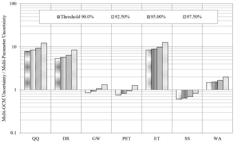
The quantification of uncertainty in the ensemble-based predictions of climate change and the corresponding hydrological impact is necessary for the development of robust climate change adaptation plans. Although the equifinality of hydrological modeling has been discussed for a long time, its influence on the hydrological analysis of climate change has not been studied enough to provide clear ideas about the relative contributions of uncertainty contained in both multi-GCM and multi-parameter ensembles to the projections of hydrological components. We demonstrated that uncertainty in multi-GCM ensembles could be an order of magnitude larger than that of multi-parameter ensembles for direct runoff projections, suggesting that the selection of appropriate GCMs should be much more emphasized than that of a parameter set among behavioral ones. When projecting soil moisture and groundwater, on the other hand, the hydrological modeling equifinality was more influential than the multi-GCM ensemble uncertainty. In addition, uncertainty in a hydrological simulation of climate change impact was much more closely associated with uncertainty in the ensemble projections of precipitation than temperature, indicating a need to pay closer attention to the precipitation data for improved modeling reliability. Uncertainty in the ensemble projections of the individual hydrological components showed unique responses to uncertainty in the precipitation and temperature ensembles. This study also proposed a framework to quantify the contributions of individual GCMs incorporated towards the overall uncertainty of hydrological climate change assessment.
Recently, the Intergovernmental Panel on Climate Change (IPCC) launched the Coupled Model Intercomparison Project Phase 5 (CMIP5) in the fifth Assessment Report (AR5), whereby a multiple general circulation model (multi-GCM) ensembles analysis was facilitated through the provision of climate model outputs that comply with community standards. The multi-GCM ensembles have served as a framework for accommodating probabilistic approaches in interpretation of climate change predictions and decision-making processes, and ensemble averaging can improve the accuracy of a climate projection by allowing GCM errors cancel each other out. The latest project output, CMIP5 has known as the most advanced generation of climate models, and thus it is desired to use them in new climate change impact studies. However, it has not been extensively utilized in climate change impact analysis yet due to the relatively short exposure to the public. Many climate models and their projections are currently available, but climate change studies have employed only a few of them depending on the preference of a modeler and the ease of use, which leads to the neglect or underestimation of uncertainty and bias in the ensemble predictions of climate change. In addition, there is no study identifying GCMs that is the most appropriate to Florida in terms of the reliability and accuracy as Florida has extreme regional and localized weather events such as hurricanes and heavy rains. This study is developing an ensemble of comprehensive climate projections for Florida using the up-to-date climate models and scenarios.
-
SWAT+ vs. SWAT2012
SWAT+ vs. SWAT2012
September 20, 2018
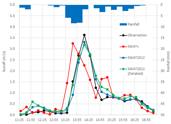
The current FORTRAN codes of SWAT (SWAT2012) are being rebuilt to ease new model and module development by incorporating object-oriented programming techniques into defining spatial objects and calculating variables. SWAT+, the new SWAT code, is expected to offer flexible watershed representation with linked spatial objects. Ideally, SWAT+ produces outputs that are comparable to SWAT2012, if not identical, when the two versions of the SWAT model are set with the same input for a watershed. However, the drastic restructuring of the source code may cause unexpected results in the output especially compared with the current SWAT2012 model that has a long history of model validation published in numerous research papers. In this paper, we compare sub-daily, daily, and monthly hydrographs provided by the SWAT2012 and SWAT+ models that were prepared for a small urban watershed located in Austin, Texas. The model parameters were calibrated to 15-min and daily runoff observed in the watershed. Then, the performance of the models was compared to each other to evaluate the differences in the simulated hydrographs. This paper provides ideas of how SWAT+ is organized and if a SWAT modeler can keep consistency in modeling results when shifting from the original to the new codes. In addition, this study makes recommendations for improved urban SWAT modeling.
-
Multi-Objective Parameter Calibration
Multi-Objective Parameter Calibration
September 20, 2018
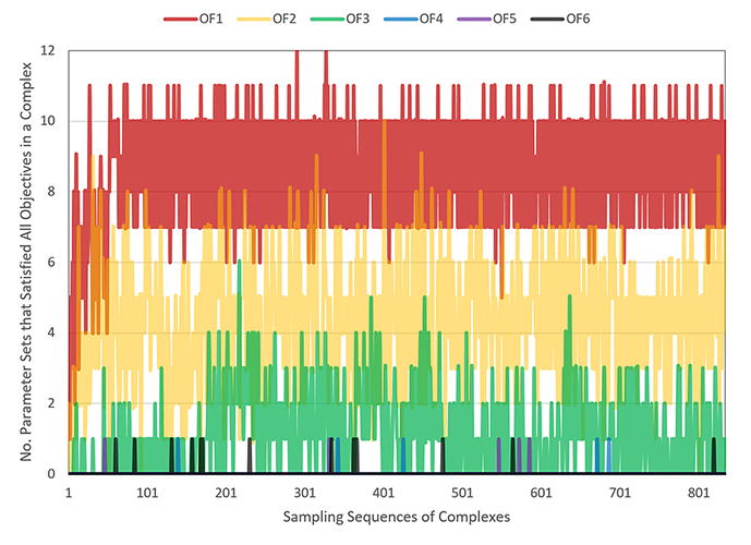
Multi-objective calibration can help identify parameter sets that represent a hydrological system and enable further constraining of the parameter space. Multi-objective calibration is expected to be more frequently utilized, along with the advances in optimization algorithms and computing resources. However, the impact of the number of objective functions on modeling outputs is still unclear, and the adequate number of objective functions remains an open question. We investigated the responses of model performance, equifinality, and uncertainty to the number of objective functions incorporated in a hierarchical and sequential manner in parameter calibration. The Hydrological Simulation Program – FORTRAN (HSPF) models that were prepared for bacteria TMDL development served as a mathematical representation to simulate the hydrological processes of three watersheds located in Virginia, and the Expert System for Calibration of HSPF (HSPEXP) statistics was employed as objective functions in parameter calibration experiments. Results showed that the amount of equifinality and output uncertainty overall decreased while the model performance was maintained as the number of objective functions increased sequentially. However, there was no further significant improvement in the equifinality and uncertainty when including more than four objective functions. This study demonstrated that the introduction of an adequate number of objective functions could improve the quality of calibration without requiring additional observations.
-
Hydrologically Sensitive Areas
Hydrologically Sensitive Areas
September 20, 2018
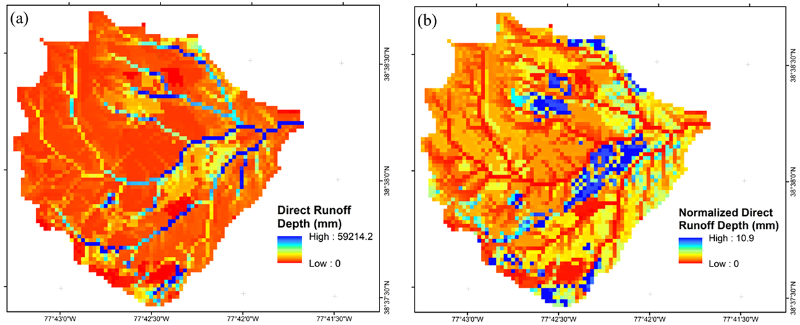
Hydrologically sensitive areas (HSAs) largely control watershed response to rainfall, along with water and pollutant transport processes. Thus, their identification is critical in watershed management planning. Although watershed processes have been studied enough to provide a good understanding of HSA dynamics, there are only a few concepts and methods available for HSA delineation and they rely on spatial indices that do not consider temporal variation in hydrologic processes. This study introduces alternative concepts and methods to delineate HSAs. Three unique maps showing watershed dynamics were created using the outputs of a long-term hydrologic simulation implemented with a grid-based distributed model. The spatial distributions of HSAs identified using the newly proposed methods were compared with those of topographic indices. Results demonstrated that the new methods highlight transport processes, such as routing (or connection) and travel time, and the roles of soil and land covers, which have not been the focus of other concepts and approaches for HSA identification. In contrast to topographic-index based approaches, the proposed methods provided HSA boundaries with clear physical meanings so as to improve the interpretability and applicability of HSA maps. The methods are expected to enhance our ability to tackle water issues for improved water resources management by providing unique concepts and alternative ways to explicitly delineate HSAs.
-
Climate Change in Florida’s Agriculture
Florida's Climate: Changes, Variations, & Impacts
Chap. 8: Climate Change Impacts and Adaptation in Florida’s AgricultureNovember 30, 2017
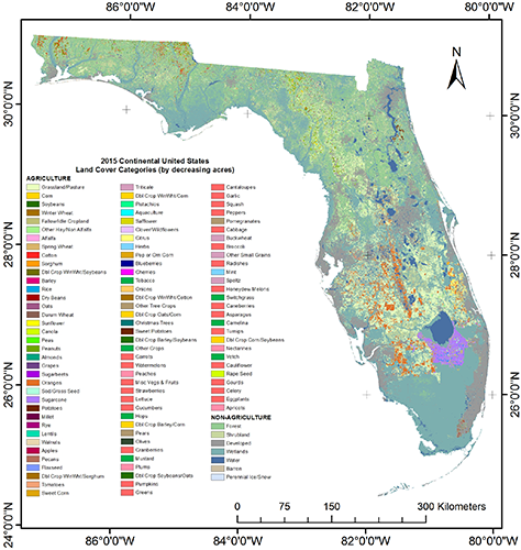
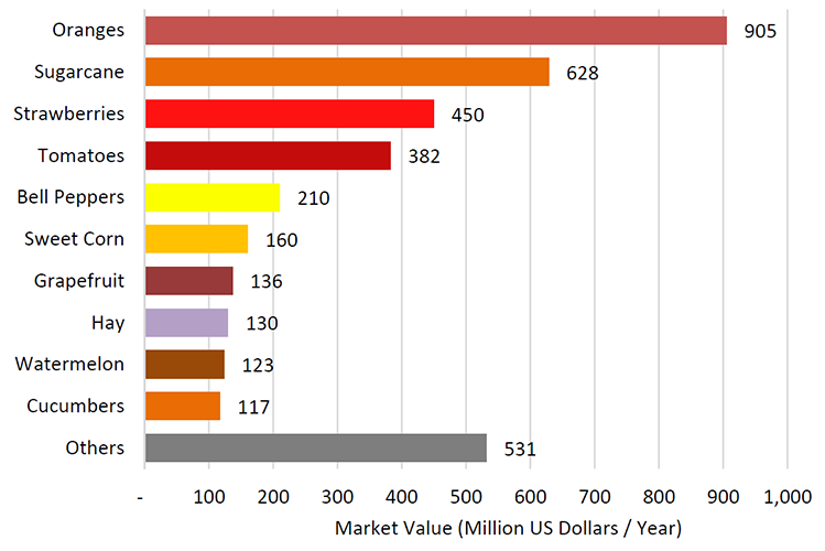
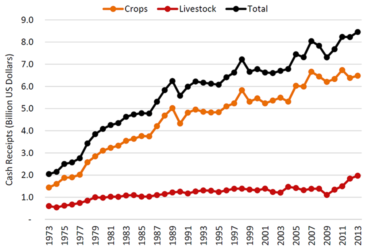
In this chapter, we describe Florida’s agriculture, the vulnerability of its crops and livestock to climate change and possible adaptation strategies. Much of Florida’s agricultural success is linked to its moderate climate, which allows vegetable and fruit crop production during the winter/spring season as well as the production of perennial crops such as citrus and sugarcane. In addition, there is a substantial livestock industry that uses the extensive perennial grasslands. While rising CO2 is generally beneficial to crop production but detrimental to nutritional quality, increase in temperature will cause mostly negative effects on yield. Florida’s agriculture faces additional challenges from climate change characterized by sea-level rise and intensified extreme climate events, affecting land and irrigation water availability, livestock productivity and pest and disease pressure. New technologies and adaptation strategies are needed for sustainable agricultural production in Florida, including increased water and nutrient use efficiency in crops, crop and livestock breeding for heat stress, pest and disease resistance and reduced exposure of livestock to high temperature. Irrigation is a favored adaptation but places an even greater burden or potential conflict between agriculture and community use of water resources.